PT 5 - Nepal 2016 - Final thoughts
Normally I like to spend a few days...
Packing up and heading home
Normally I like to spend a few days after a long cycle trying to absorb the experience and generally ease out of the touring mindset. On this occasion, almost immediately after unpacking my things and settling back into my hotel room, I start to feel restless. I take a long walk through town but it’s just not the same, the hooting, the incessant sales pitches, constant jostling of the crowds and threat of been knocked down in the traffic.

The façade of this trekking tourism area crumbles down around me and for the first time I see that its all an illusion, the traditional buildings, local dress, friendly conversations, colorful merchandise, fake, fake, fake. I know its an overreaction, a symptom of been exposed to the real Nepal for too long, but I can’t stay.

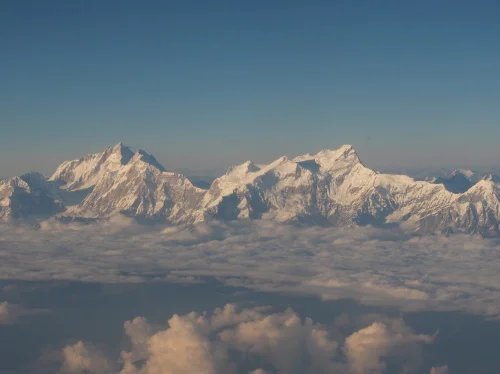
I go online and change all my flight bookings so that I can leave the following day. Later that evening I dismantle my bike but can’t remove one of the pedals, so it’s a really tight fit in the already slightly too small bike bag. The next day, we take off in the late afternoon and fly all along the Himalayan mountain range. I am on the wrong side of the plane, craning my neck to get a glimpse of the mountains when a couple on the correct side see me and offer to change seats for a while. I refuse politely for the required period then accept, jamming my camera up against the window.

There before me, rising above the clouds like a giant crocodile’s tail are the Nepalese Himalayan mountain chain, glistening white and spectacular in the diffused light of a late afternoon. After a brief spell, I go back to my seat and promise to send them a set of photos taken from the plane.
The sun sets, and dinner trolleys are rolling down each of the two isle.
In the final analysis
So now, after some time has gone by, I need to find the answer to two very important questions;
Did I chicken out over the pass?
Does it matter?
To take the first question first.
By the time I got up in the morning before the final push towards the pass, my headache had gone, so probably I would have been ok to have carried on. The weather was clear and expected to be good for the next few days, so chances were that although it would still have been extremely cold, it was unlikely to have turned critically bad. There were many groups of trekkers, guides and porters on the trail by this stage, so I wouldn’t have been completely alone over the pass if I did get into difficulty.
The shortness of breath during that night was definitely a problem related to gaining altitude too fast, but I could have gone back down to Manang and spent another day or two acclimatizing. So taking all that into account, I think I probably could have carried on and safely negotiated the pass, it could have been really cool. So, did I chicken out over the pass?
“Hell yes!”

On the second question;
Although I had heard about the pass before, it had never been a goal of mine to try to cross it on this trip. My intention was to get up close to the mountains just to see for myself what they would look like It was only after I spoke to people in Nepal that I considered it as a possibility and even on the trail when people would ask if I was going to do the pass, my answer was always along the lines of, “I’m just going to keep cycling until I stop, and if that’s the other side of the pass then fine, if not, then also fine” While the landscape and scenery on the Annapurna circuit was breathtaking and the riding just amazing, from a cultural aspect it was all but destroyed. Most of the villages have converted over to tourist towns, menus have been standardized at ALL the tea rooms and there is really very little left that could be called authentic. There are tourist check points, medical aid posts, purified water outlets, shops, movie houses and literally 1,000’s of trekkers, guides, porters, pack mules and now Boleros in an endless procession along the trail.
It was only while travelling in the areas outside of the trail, which was the larger part of the trip, that I was able to experience Nepal for what it really is, and appreciate the subtle changes in its culture and people as I moved between the highlands, midlands and low lying regions. There were no tourists on my route, no standardized accommodation or menu’s written in English, no route markers or check points. That’s what I really wanted to experience, that’s what Dylan and I had experienced during our Bhutan to Kathmandu cycle in 2015. So did it really matter that I didn’t go over the pass?
“Hell no!”

Bike, luggage and equipment
Bike.
GIANT XTC 3 SLX 27’5-inch hard tail mountain bike (2015) with MAXXIS CROSSMARK tires.
After a comprehensive service at Himalayan single track in Kathmandu, I suffered no mechanical or any other problems on the ride, only replacing the rear disc pads in Pokhara as a precaution. I had a single puncture, and the tires held air for the entire trip without even the need for topping up, which seemed a little silly really.

Luggage
30lt Deuter Trans alpine 30lt backpack.
Thule pack and pedal rear rack.
10lt dry bag.
As is my custom for this level of bike touring, I stuck with a 30lt backpack, but because the possibility of extreme cold existed, added the rear carrier to accommodate a dry bag full of bulkier clothing.
The quality of the Deuter pack is excellent and it was well balanced and comfortable on my back. There was plenty of versatility in terms of compartments to organize all my kit. I packed everything in separate dry bags or zip lock bags for added protection, but mainly because it makes organizing kit so much easier.
I had heard mixed reports about the Thule rack, mainly that the bolts worked loose and need tightening a few times a day. This was not my experience, although I checked each morning, everything remained secure.
I also had a small bar bag for my cellphone and daily cash, but a tear in the side pouch caused me to loose a camera battery and my lovely penknife given to me by my son Dylan after our Bhutan cycle in 2015. I replaced this in Kathmandu before returning home.

Camera equipment:
Olympus - OM-D M-E1 Micro 4/3 digital camera
GOPRO Session
M-ZUIKO lens - Standard zoom 12-40mm f2.8 (24-80mm f5,6 FF equivalent)
M-ZUIKO lens - 17mm f1.8 (34mm f3.6 FF equivalent)
M-ZUIKO lens - 25 mm f1.8 (50mm f3,6 FF equivalent)
M-ZUIKO lens - 75 mm f1.8 (150mm f3,6 FF equivalent)
SLIK Mini pro - table top tri pod

I struggled terribly with taking a decision as to which camera set up to bring on the trip and on the morning I flew out from Lao, I still had both my Canon 5D and the Olympus micro 4/3 sets lined up next to each other. My final decision to go with the Olympus was based on the rationale that due to weight considerations, I would not be able to take the range of lenses needed to justify taking a full frame camera in the first place. With the Olympus, I was able to take 3 prime lenses and a good quality zoom at half the weight and bulk of the Canon with only one decent prime lens.
In retrospect, I never really missed having a full frame camera with me and I honestly cannot complain about the quality of the images I brought back. It was the right decision.

The other stuff
For me personally, there is something special about travelling on a bike that’s free of luggage. Somehow the set up maintains within my psyche a “Hey, I think I’ll just go for a quick ride on my bike” frame of mind. for me, I have this style of touring down to an art form, with plenty of luxury items included in the mix, loads of camera equipment and separate clothing for the evenings. In fact, looking at the list of items I took with, its difficult to imagine how I fitted it all in, but it was completely manageable, even comfortable. There was nothing I didn’t use, other than the “insurance items” such as spares, first aid and contingency stuff.

In particular, the electronics section appears to be over the top, but every item was used on a daily basis and made it possible for me to keep in contact with my family and friends, check my routes and even enjoy nightly entertainment in the worst of conditions. (Black Adder and Flight of the Conchords)

Overall route statistics

Distance - 1,013 km
Average distance per day - 63 km
Highest milage in one day - 154
Total elevation climbed - 14,420
Ave elevation climbed per day - 901
Most climbing in one day - 1,658
Highest elevation reached - 4,232 MASL
Lowest elevation reached - 103 MASL
Swannie's Little Karoo Cycle - 1949
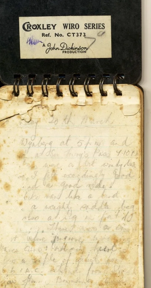
Left Wynberg at 5 pm and arrived at Sir Lowry’s Pass 7.10 Pm. My legs were a bit wobbly but …
Swannie's Little Karoo cycle - 1949

Last month while rummaging through a box of my dad’s belongings during my home visit, I came across an old diary of a cycle trip he had done through the little Karroo as a young man. The pages were stained and yellowed with age. I remembered him showing it to me a few times when I was younger, but I never showed much interest then. With the help of my mom and sister Ellen, I have managed to decipher most of it and found it to be a lovely story of a young man on an adventure, not a world taming, record breaking feet of glory, but an adventure of the common man, similar in many ways to trips of my own.

The diary entries are from 1949, when he was a young man of 25 years old working his apprenticeship at Norton Motors in Cape Town. He and a fellow cyclist had been dreaming of cycling together through Europe, and this short trip was to be a test to see if they were up to the task. When his friend cancelled, my dad decided to continue with the Karoo trip and see where it would take him.

Route map and location of some of the main areas visited
Sunday 20th March (First page mostly unreadable)
Left Wynberg at 5 pm and arrived at Sir Lowry’s Pass 7.10 Pm. My legs were a bit wobbly but …. I felt exceedingly good …. and had a good ride. The bike went like a bird in spite of a weighty saddle bag and also a bag in front of the bars. There was a van on fire at …. anybody here …. nobody hurt …. Henry Brownings .… family ……..

I retired early and had a good night’s rest. How good and exhilarating it is to wake up in the morning and find yourself among all these beautiful mountains and countryside.
Monday
Left Sir Lowry’s pass at 9 am and travelled via Somerset West, Stellenbosch, over Hells Hoogte, Simondium. and then on to Paarl. By that time, it had already become unbearably hot and I decided to put on my cap! only to find that I had either left it at Sir Lowery Pass or lost it along the way. I thought of the toil up Baines Kloof and the definite need for some headgear and bought a cap at Paarl. I only arrived at “Nonna”, Mr Rabie’s farm at De Wet at 7:45pm after taking the wrong road at Worcester.

Bain's Kloof
Distance travelled approx 90m (144km)
Tuesday
Spent a lovely day at the farm and spent some time at the wine kelders at
De Wet.

Wednesday
Left at 5:30am and got a 25-mile (40km) lift on a lorry owned by a Mr. De Wet. Arrived at Laingsburg 12:45pm after having a bit of trouble with front wheel spokes. Got a room at the Grand Hotel and spent the afternoon messing around with spokes instead of, as I felt inclined for, a good sleep. However, a couple of good meals and a good night’s rest put me on the road the next morning at 6:15 again.
Distance travelled 93 miles (150km)
Thursday
About 18-miles out of Laingsburg felt very tired indeed and thought of getting a train. Just then met a farmer Oom (Uncle) Piet Le Roux who was trekking for better pastures with his flock of sheep. He was very kind indeed and offered great chunks of boere (farm style) raisin bread and coffee which I must say, I greedily devoured. After spending about an hour with this Oom I arrived at Prins Albert St. at 11 o'clock. I hired a room at the Karroo Hotel and after a good meal tried to have a sleep which was almost impossible due to the intense heat.

I left again at 5:30pm and arrived at the dorp at 8pm after a ½ hour of grim time riding, riding in the dark on these badly corrugated roads with very loose sand at the sides and also the possibility of a snake or some other reptile parked in your path makes it quite an experience when visibility is just about nil.

Prins Albert
Distance travelled 81 miles (130km)
Monday 28th March

Left Prins Albert at 7:15am and arrived at the Cango caves at 10:30, just too late for first expedition into caves and so had to wait till 12:30. After a very interesting trip through the Caves (only a personal trip to these caves can describe this wonderful works of nature) I Left again at 3:15 and arrived in Oudtshorn at 4:45. Spent the night at the Central Hotel and saw a bit of the town.
Distance travelled 43 miles (69km), this included Swartberg pass which is definitely breathtaking. Have never experienced a pass so steep and also so high above the surrounding Country. The road is narrow and extremely loose which necessitates for very slow descent, also having to stop at intervals to allow brakes to cool down.

Swartberg Pass
Tuesday
Left Oudtshoorn at 7:15am arrived at De Rust 10am. Proceeded through Meirings poort and when midway, was picked up by lorry driver Mr. De Jager who brought me through to Klaarstroom. After a good meal with the De Jager family left on on last leg of the trip. At 12:30 pm and arrived back in Prins Albert about 4:45
Distance travelled 70 miles. (112km)

Back at Prins Albert I spent two lovely quiet weeks simply just eating and sleeping with occasional short cycle trips up the pass and also the near surrounding districts. One of my objectives was also to make a visit to a very queer and out of the way place known as the “Hell”. It is situated about 35 miles (56km) out of Prins Albert in the heart of the Swartberg mountains. It consists only of a small community of people mainly farmers who rely only on their land and stock for their living.
To reach the hell one has to walk along the bed of the Gamka river and pass through a very narrow poort. When the river is in flood or is raining fairly strong, the hell might then completely be cut off from the outside world for days or maybe weeks. Inside the poort the mountains, I believe, are still teaming with leopards and game. From the time one enters the Poort until the first farmhouse is sighted is about 15 miles and due to the inaccessible nature of the place only pack donkey’s or mules are used for transport.

This is what I had to listen to for many a quiet evening in Prins Albert when earnestly enquiring from well known characters how to get to the Hell. I was told that the people there were of a very wild, almost ape-like nature and would sort of tear you apart without the slightest fuss. Most people persuaded me not to attempt the venture, at least not unaccompanied. I abandoned the idea then but was quite sure that had my stay been longer, I would surly have gone there some time or other.

Road to "The Hell" only build after Swannie's trip
This is where I semi cursed the wheels of progress for only allowing a man 1/12 of a year holiday annually. Personally I think the world would still carry on if our annual leave were increased to 3 months so that we could fully appreciate this lovely country of ours. To be up before dawn in the unlimited spaciousness of the Karroo and breathing in the crisp fresh air makes one loathe to go back to the stuffy and bustling atmosphere of a city.

Tuesday 8th April
Left Prins Albert at 11:30a.m and set out for the station 28 miles distant. I was in high spirits
and absolutely as fit as a man could be. I must say that this was the way that I felt right through the course of my trials. I can’t at any time remember feeling down and out or depressed when thinking of my fairly big undertaking in hand, or also while experiencing several 5am rises. I thought this was understandable due to the perfect change in the air kind people, in fact everything as far as I was concerned.

The food that I had since leaving Wynberg was different to what I was used to, sort of rough and ready and also in greater quantities. For my part I could never eat enough and when I did happen to satisfy my enormous appetite was scolded upon by my very find hosts who wanted to know how I liked the sample and when I was going to get stuck in. Some of these “barrel” like farmers can really eat, and regard you with an air of amusement when having my comparatively small plate of rys, vleis and artapples (Rice, meat and potatoes) or if I should tell them what some people have for dinner in Cape Town.
After traversing a series of steps in the road I crossed the drift at Gamka River and from there, the road was comparatively flat and uninteresting. I preferred “steps” to long monotonous uphill’s as the speed carries you to the top of a short hill and from there level to be followed again by a short hill. In this way, height could be easily gained without getting overtired. I arrived at the station at 12 noon and I consider It a speedy ride though I did not intend doing any fast strenuous riding.
It’s understood that he loaded his bike onto the train for the trip back to Cape town.
Trans Karoo 2007
For the third time in less than an hour, I lay sprawled alongside my bike,....
Trans Karoo 2007

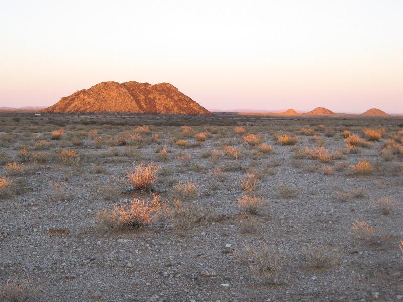
For the third time in less than an hour, I lay sprawled alongside my bike, a victim of the soft curry-powder sands of the Kalahari. Alone and despondent, under a charcoal sky, the fantasies of my adventure became reality.
Distance travelled: 8 km. Distance to go: 1 392 km.
Ever since, as a novice mountain biker, I had won the Freedom Challenge I had begun to suspect that in reality, the opposite of possible is not impossible, but simply “frigging difficult”. That the difference between average and amazing lay not in the chains of a double helix, but in hard work, detailed planning, careful preparation and, more importantly, passion.

And so, after shaking the sand from my ears, refitting the chain and adjusting my rucksack, I skidded, fell, cycled and pushed my way straight into the path of my first Kalahari sunrise.

I had always wondered about the Great Karoo, what I would find in its remoteness, what it would find in me. After many hours bending over piles of maps and squinting at Google Earth, I produced a bright purple line on my map running down the breadth of our country. Following only dirt roads and tracks, my route extended from Askham, on our border with Botswana, through the red sands of Gordonia, the plains and salt pans of Bushmanland, past the koppies of the Great Karoo and over the Swartberg Mountains, to exit the Little Karoo via the Langeberg Mountains, ending at my home in Swellendam.

The Freedom Challenge had taught me many important lessons; like how to travel light and how to keep motivated when covering ridiculous distances for weeks at a time, but it could never have prepared me for the immense mental struggle of riding day after day in country as flat as this. With no hill or valley to break my stride or change my pace, no distant mountains to play with my mind, every km was a mental marathon. I developed strategies to distract myself from any clue of distance and time, but inevitably my mind would continue its relentless countdown: 140 km ... 139 km ... 138 km. To maintain a reasonable forward speed you have to keep pedalling ALL the time.

I must confess that there were times when I gave in to the self-willed child within me, stopped the bike in the middle of the road and pounded the handlebars in utter frustration. Fortunately, the calm, disciplined adult me would gently take back the reins, and together we would set off towards the next km mark on the flat endless ribbon ahead.

So I moved steadily down the line: Askham, Swartstraat, Upington, Kenhardt.
Lying in my hotel bed at Kenhardt, covered with a mountain of down, I watched the weather reporter pointing to the general area of the Great Karoo where little animated rainclouds splashed raindrops onto my route. I drifted into dreamland with these rainclouds turning slow circles through my dreams. Tomorrow, I would be at Verneukpan.

Verneukpan fascinated me – a great saltpan sploshed on the map like a wet bird dropping. Maybe because it was the only real feature that stood out on a map between Askham and Fraserburg, or because it was where Sir Malcolm Campbell broke the land speed record. Either way, I was looking forward to riding over it.

At 5 am I stepped outside into a strong, cold wind, and headed off into the darkness. No friendly sunrise greeted me this morning, and the dawn revealed ominous low, brooding clouds in the direction I was heading. I just managed to gear up for the worst when the first icy drops started falling. By the time I reached the pan, large shallow lakes had formed in every direction. I had expected an easy passage across the vast flat plain, but I was very much mistaken.

The rain had turned the smooth expanse of the pan into a quagmire of thick porridgy clay that built up on my bike (and me) to such an extent that any hope of riding was dissolved. All moving parts jammed solid and the weight added to my bike by the build up of clay made it impossible to carry. Scraping off as much of the sticky porridge as possible, I hauled the bike on my shoulder, staggering a few meters at a time before either succumbing to the weight, or falling heavily onto the squishy surface. All things, even bad things, come to an end, and it was with relief that I finally placed my bike down and found that it was on firm ground. It had taken me four hours to move 2 km!

At the farmhouse on the opposite side of the pan, I listened to stories of speed attempts that had ended in tragedy here, how the vast flat plain can distort one’s perception of distance and size, and how people have got lost – disoriented by its vast expanse. I started to feel somewhat privileged that I too had been verneuked by the pan.

The next few days through Williston and on to Fraserburg were some of the coldest I have ever endured. Carrying the right clothing for the sub-zero temperatures I experienced each morning was a challenge, especially when my entire kit needed to fit into a single 28-litre backpack. Although unbelievably cold, the mornings were the best part of the day, and I revelled in the surge of adventure I felt, setting off alone into the dark unknown. Lost in a cold world, I would become vaguely aware of the pending sunrise, and then an almost unbearable cold snap would occur just before the dawn.

The appearance of the sun above the horizon always caused me to stop and celebrate the new sights and sounds around me. At that moment, everything about my trip would make sense, and I would understand exactly why I was out there.

From Fraserburg, the land underwent a dramatic change, and for the first time since starting the trip six days previously, I rode among mountains. I cannot explain just how wonderful it was to drink in the natural eye candy of the Nuweveld Mountains around me, steep slopes capped with granite, pools of ice along winding roads. Riding silently under a full moon, I soaked in the beauty around me. After hugging the “Steep Descent” signboard at the watershed, I poured water over my gears to melt the ice, and then allowed the large chainring to toss me off the escarpment where the last vast plain of the Great Karoo waited to lead me to Leeu Gamka. Looming cheerfully in the distance lay the Swartberg Mountains.

At Leeu Gamka, I collected my parcel containing maps, spares and other essential supplies which I had sent 'Poste Restante' (they just love it when you talk foreign!) to the local post office. This was one of two such parcels I had forwarded along the route, and the system worked well.

A good night’s sleep in Prince Albert assured me of an early start, and soon I was pedalling under a full moon towards the familiar Swartberg Pass. The scene around me was breathtakingly beautiful. A Land Rover edged past me in the darkness, and it was fascinating (although slightly alarming) to watch the headlights stitching their way through the hairpins higher and higher till they finally disappeared at an impossible angle above me.

I arrived at the top of the pass just after sunrise, and lay on my back with the Karoo and Nuweveld Mountains framed between my shoes. It was beautiful, and a little sad, as if reading the final chapters of an amazing book. With a last glance to the north, I turned my back and headed down towards the Little Karoo, and the Langeberg Mountains in the distance.

My final day from Calitzdorp to Swellendam via the Rooiberg was epic. Over 200 km of undulating dirt road and relentless headwinds awaited me. Leaving the small town of Van Wyksdorp for the final stretch, things began to get a little silly.
I developed a sharp pain in my knee that got worse as the day progressed. In sympathy, my bottom bracket (the one on the bike!) started developing some play, making a 'cluck, donk' noise which is slightly worse than a 'click, click' noise but not nearly as bad as the 'cluck, clang' noise. So if you happened to be lying in the fields on the side of the road as I came past, you would have heard something like:
'Cluck / donk / creak (knee joint) / $!&#*! Cluck / donk / creak / &!#*^!’

Anyway, the result of it all was a rather slow, painful passage along the northern slopes of the Langeberg. I made it through to Barrydale just as the sun set and with 44 km left, it was only the Tradouw Pass and its vagrant leopard that stood between me and my own bed. Both knees were complaining as I rode the last few km along the N2, with trucks, buses and cars whizzing past me. What a contrast from the vast open plains of Bushmanland and the quiet Karoo.

Just past nine, I ground slowly up the last steep section of dirt road that separates my home from the town of Swellendam. I lay on the cold grass outside my house, delaying the end of my adventure a little longer. Looking up at the towering shadow of the Langeberg, my mind drifted back to the moments that would for me always define this trip. The sweet coffee I shared with a farm worker, the generosity of the farming couple at Verneukpan and the sunrise over Bushmanland. In the dark silence, my mind explored the pools and waterfalls I knew were there in the lush ravines above me, and I thought ... 'It's good to be home.'
